 ISRIC Data Hub
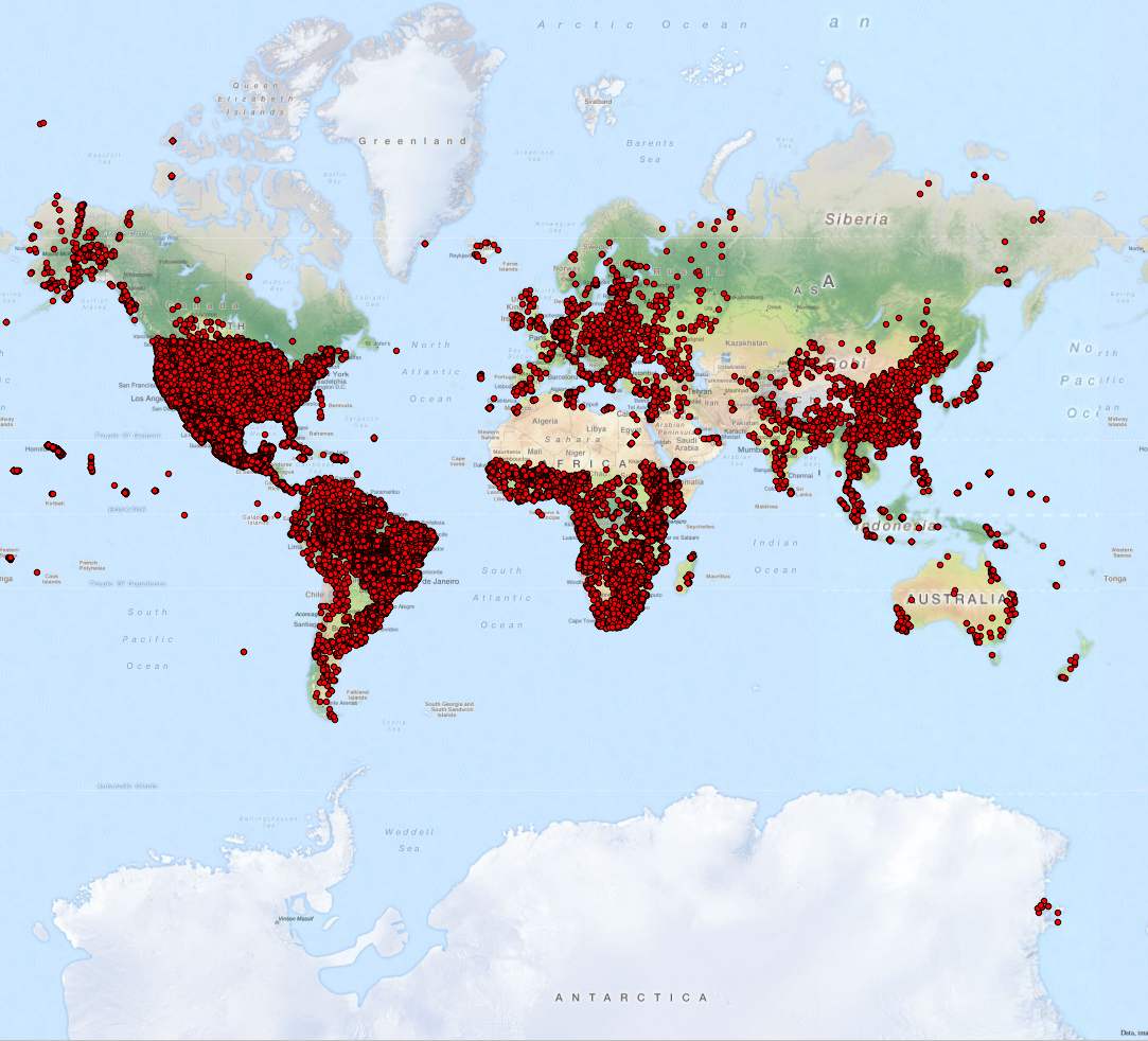
WoSIS snapshot - July 2016
The aim of the World Soil Information Service (WoSIS) is to serve quality-assessed, geo-referenced soil data (point, polygon, and grid) to the international community upon their standardisation and harmonisation. So far, the focus has been on developing procedures for legacy point data with special attention to the selection of soil analytical and physical properties considered in the GlobalSoilMap specifications (e.g. organic carbon, soil pH, soil texture (sand, silt, and clay), coarse fragments ( greater than 2 mm), cation exchange capacity, electrical conductivity, bulk density, and water holding capacity). Profile data managed in WoSIS were contributed by a wide range of soil data providers; the data have been described, sampled, and analysed according to methods and standards in use in the originating countries. Hence, special attention was paid to measures for soil data quality and the standardisation of soil property definitions, soil property values, and soil analytical method descriptions.
At the time of writing, the full WoSIS database contained some 118 400 unique shared soil profiles, of which some 96 000 are geo-referenced within defined limits. In total, this corresponds with over 31 million soil records, of which some 20 % have so far been quality-assessed and standardised using the sequential procedure discussed in this paper.
The number of measured data for each property varies between profiles and with depth, generally depending on the purpose of the initial studies. Overall, the data lineage strongly determined which data could be standardised with acceptable confidence in accord with WoSIS procedures, corresponding to over 4 million records for 94 441 profiles.
The downloadable ZIP file has the data in TSV (tab separated values). It contains the following files:
- ReadmeFirst_WoSIS_2016.pdf (148.1 KB)
- wosis_201607_attributes.txt (4.1 KB)
- wosis_201607_layers.txt (679.1 MB)
- wosis_201607_profiles.txt (8.8 MB)
Citation:
Batjes NH, Ribeiro E, van Oostrum A, Leenaars J, and Mendes de Jesus J 2016. Standardised soil profile data for the world (WoSIS, July 2016 snapshot), doi:10.17027/isric-wdcsoils.20160003.
The dataset accompanies the following data paper: Batjes NH, Ribeiro E, van Oostrum A, Leenaars J, Hengl T, and Mendes de Jesus J 2017. WoSIS: Providing standardised soil profile data for the world, Earth System Science Data 9, 1-14, doi:10.5194/essd-9-1-2017.
Simple
- Date (Publication)
- 2016-07-20
- Identifier
- 76f1bae3-cee1-4bc7-98b2-beb036d88d2b
- Identifier
- doi: / 10.17027/isric-wdcsoils.20160003
- Presentation form
- Digital map
- Status
- Completed
- Theme
-
- bulk density
- cation exchange capacity
- soil classification
- coarse fragments
- clay
- effective cation exchange capacity
- electrical conductivity
- organic carbon
- pH
- sand
- silt
- calcium carbonate
- texture
- water retention
- soil profiles
- Stratum
-
- Soil science
- Region
-
- Global
- Access constraints
- License
- Use constraints
- License
- Other constraints
- Licenced per profile, as specified by data provider and indicated in the data
- Spatial representation type
- Vector
- Denominator
- 100000
- Metadata language
- English
- Character set
- UTF8
- Topic category
-
- Geoscientific information
- Begin date
- 1918-01-01
- End date
- 2013-02-12
))
- Reference system identifier
- EPSG / 4326
- Distribution format
-
-
Niels H. Batjes
(
)
-
Niels H. Batjes
(
)
- OnLine resource
- Download zip ( WWW:DOWNLOAD-1.0-ftp--download )
- OnLine resource
- Scientific paper ( WWW:LINK-1.0-http--related )
- OnLine resource
- Project webpage ( WWW:LINK-1.0-http--related )
- Hierarchy level
- Dataset
- File identifier
- 76f1bae3-cee1-4bc7-98b2-beb036d88d2b XML
- Metadata language
- English
- Character set
- UTF8
- Hierarchy level
- Dataset
- Hierarchy level name
- dataset
- Date stamp
- 2023-12-08T11:18:44
- Metadata standard name
- ISO 19115:2003/19139
- Metadata standard version
- 2003/Cor.1:2006
Overviews
Spatial extent
Provided by
