 ISRIC Data Hub
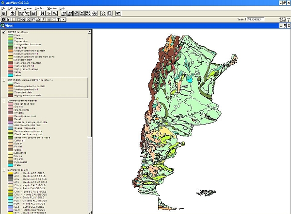
Soil and Terrain Database (SOTER) for Argentina
The Soil and Terrain database for Argentina primary data (version 1.0), at scale 1:1 million (SOTER_Argentina), was compiled of enhanced soil information within the framework of the FAO's program Land Degradation Assessment in Drylands (LADA). Primary soil and terrain data for Argentina were obtained from the SOTERLAC database (ver. 2) at scale 1:5 million. This update includes considerable changes in the GIS file, based on the SRTM-DEM derived surface information and on INTA's digital soil map (Instituto de Suelos), and only few changes of the attributes database.
SOTER forms a part of the ongoing activities of ISRIC, FAO and UNEP to update the world's baseline information on natural resources.The project involved collaboration with national soil institutes from the countries in the region as well as individual experts.
- Identification
- Distribution
- Quality
- Spatial rep.
- Ref. system
- Content
- Portrayal
- Metadata
- Md. constraints
- Md. maintenance
- Schema info
Identification
Data identification
Citation
- Date (Publication)
- 2008-10-01
- Identifier
- ee206a45-4337-4008-8d74-d737b65ba3f0
- Presentation form
- Digital map
- Status
- Completed
- Theme
-
- calcium
- carbon
- cation exchange capacity
- electrical conductivity
- nitrogen
- organic matter
- bulk density
- soil profiles
- pH
- salinity
- texture
- water holding capacity
- nutrients
- Stratum
-
- Soil science
- Region
-
- South America
- Latin America
- Argentina
Legal constraints
- Access constraints
- License
- Use constraints
- License
- Other constraints
- Attribution 3.0 International (CC BY 3.0)
- Spatial representation type
- Vector
- Denominator
- 1000000
- Metadata language
- English
- Character set
- UTF8
- Topic category
-
- Geoscientific information
- Begin date
- 1968-04-01
- End date
- 1991-04-01
))
Distribution
Distribution
- Distribution format
-
-
zip
(
)
-
zip
(
)
Digital transfer options
- OnLine resource
- Download ( WWW:DOWNLOAD-1.0-ftp--download )
- OnLine resource
- Project webpage ( WWW:LINK-1.0-http--related )
- OnLine resource
- Report ( WWW:LINK-1.0-http--related )
Quality
Data quality
- Hierarchy level
- Dataset
- Statement
- Dijkshoorn JA, van Engelen VWP and Huting JRM 2008. Soil and landform properties for LADA partner countries (Argentina, China, Cuba, Senegal and The Gambia, South Africa and Tunisia). ISRIC report 2008/06 and GLADA report 2008/03, ISRIC – World Soil Information and FAO, Wageningen, https://isric.org/sites/default/files/isric_report_2008_06.pdf
Ref. system
- Reference system identifier
- EPSG / 4326
Metadata
Metadata
- File identifier
- ee206a45-4337-4008-8d74-d737b65ba3f0 XML
- Metadata language
- English
- Character set
- UTF8
- Hierarchy level
- Dataset
- Hierarchy level name
- dataset
- Date stamp
- 2021-07-14T11:52:36
- Metadata standard name
- ISO 19115:2003/19139
- Metadata standard version
- 2003/Cor.1:2006
Overviews
Spatial extent
Provided by
