Global Assessment of Land Degradation and Improvement (GLADA)
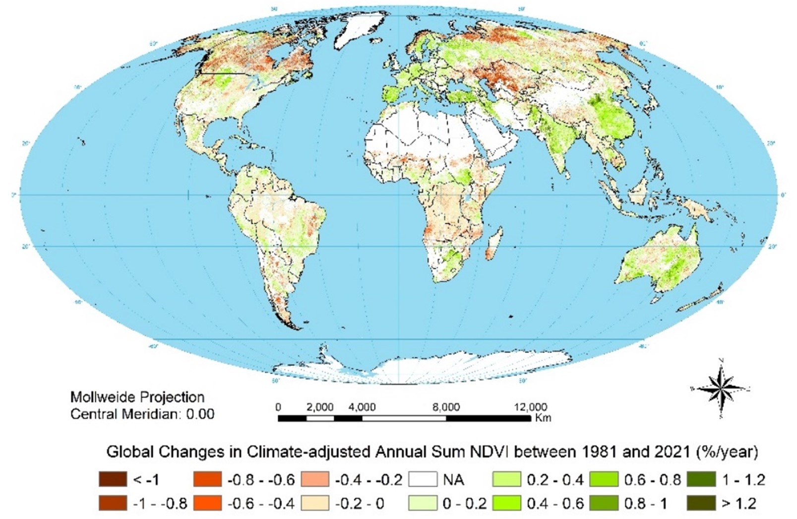
The Global Assessment of Land Degradation and Improvement (GLADA) project (2006–2009) was part of the GEF–UNEP–FAO program Land Degradation in Drylands. It utilized remote sensing data to identify areas experiencing land degradation as well as regions where degradation had been halted or reversed. The study relied on analyses of vegetation greenness using the Normalized Difference Vegetation Index (NDVI) as a proxy for net primary productivity, adjusted for the effects of climate variability on biomass through rain-use efficiency and energy-use efficiency.
Biomass represents an integrated measure of biological productivity, and deviations from the local norm can serve as indicators of land degradation or improvement. Changes in biomass can be monitored via remote sensing of NDVI—the difference between reflected near-infrared and visible wavebands divided by their sum. NDVI is strongly and linearly correlated with the fraction of photosynthetically active radiation absorbed by vegetation, as well as with vegetation cover and above-ground net primary productivity. Baseline norms can be established by stratifying land areas based on climate, soil, terrain, and land use or vegetation type. Deviations from these norms may then be assessed regionally and aggregated globally to enable universal comparisons.
Although the GLADA project concluded in 2009, its datasets and maps have been periodically updated as new remote sensing and climate data have become available, extending coverage to approximately 2021.
The GLADA dataset comprises two primary raster layers presented in percentage: (1) global land degradation 1981-2021 and (2) global land improvement 1981-2021. Further details about the data can be found in the associated metadata and project documentation.
Simple
- Date (Revision)
- 2021-12-31
- Citation identifier
- 324bd0cd-fb10-498a-864f-4059a2e43046
- Status
- Completed
- Point of contact
-
Organisation name Individual name Electronic mail address Role ISRIC - World Soil Information
Zhanguo Bai
Author
- Theme
-
-
land degradation
-
land improvement
-
global
-
-
Stratum
-
-
Soil science
-
-
Region
-
-
global
-
- Access constraints
- License
- Use constraints
- License
- Other constraints
- Attribution 3.0 International (CC BY 3.0)
- Spatial representation type
- Grid
- Language
- English
- Character set
- UTF8
- Topic category
-
- Geoscientific information
- Begin date
- 1981-01-01
- End date
- 2021-12-31
))
- Reference system identifier
- EPSG / 4326
- Distribution format
-
Name Version image/tiff
- Distributor contact
-
Organisation name Individual name Electronic mail address Role ISRIC - World Soil Information
Data infodesk
Publisher
Digital transfer options
- OnLine resource
-
Protocol Linkage Name WWW:DOWNLOAD-1.0-http--download
https://files.isric.org/projects/glada/Negative_RUE-adjusted_Annual_Sum_NDVI_Change_1981_2021_percentage.tif Negative_RUE-adjusted_Annual_Sum_NDVI_Change_1981_2021_percentage
WWW:DOWNLOAD-1.0-http--download
https://files.isric.org/projects/glada/Positive_Climate-adjusted_Annual_Sum_NDVI_Change_1981_2021_percentage.tif Positive_Climate-adjusted_Annual_Sum_NDVI_Change_1981_2021_percentage
- Hierarchy level
- Dataset
- Statement
-
Bai Z., Russ J.D., Mayr K.F., Dent D., 2025. How is Gaia doing? Trends in global land degradation and improvement. Ambio doi: https://doi.org/10.1007/s13280-025-02179-9
Metadata
- File identifier
- 324bd0cd-fb10-498a-864f-4059a2e43046 XML
- Metadata language
- English
- Character set
- UTF8
- Hierarchy level
- Dataset
- Hierarchy level name
-
dataset
- Date stamp
- 2025-11-28T15:07:11
- Metadata standard name
-
ISO 19115:2003/19139
- Metadata standard version
-
2003/Cor.1:2006
- Metadata author
-
Organisation name Individual name Electronic mail address Role ISRIC - World Soil Information
Data infodesk
Point of contact
)))
