Soil property datasets produced in cup4soil project - Beta version
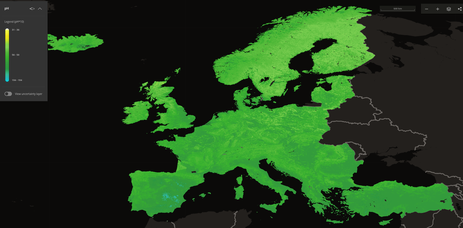
These datasets were prepared within the scope of the CUP4SOIL (Copernicus user uptake for soil information products) project (Copernicus user update project). The soil property maps were generated at a resolution of 20m, and created with LUCAS and other continental level data using digital soil mapping. Users should assess the local ''predictive'' accuracy of the maps prior to using them for making recommendations at local (or field) level.
The datasets contain the following soil properties (for top soil (0-30 cm) depth): Soil organic carbon content, pH in water, Total nitrogen, Bulk density (oven dry), Coarse fragments (volumetric), Soil inorganic carbon content, Sand, Silt, Clay. The SoilSuite products ( https://c.geoservice.dlr.de/web/datasets/soilsuite_eur_5y) were used as covariates, together with a range of other copernics products.
Measurement units and web links for the above properties can be found be below. The maps are provided as Web Map Service (WMS) layers which load dynamically in a GIS software. For instructions see:
https://www.isric.org/instruction-wms .
The suffix `_mosaic` refers to the full data (20m spatial resolution). If you need to use the data, please use layers with the `_mosaic` suffux.
The suffix `_overviews` refers to spatial overviews for faster visualisation. However datasets with the `_overview` suffix will not load to the full resolution.
Simple
- Date (Creation)
- 2025-04-16
- Date (Publication)
- 2025-04-16
- Code
- Status
- ongoing
- Point of contact
-
Organisation name Individual name Electronic mail address Role ISRIC - World Soil Information
Data infodesk
Point of contact
- Stratum
-
-
soil
-
europe
-
carbon
-
nitrogen
-
pH
-
soil organic carbon content
-
bulk density
-
coarse fragments
-
sand
-
silt
-
clay
-
soil science
-
- Access constraints
- License
- Use constraints
- License
- Other constraints
-
Attribution 4.0 International (CC BY 4.0), https://creativecommons.org/licenses/by/4.0/
- Spatial representation type
- Grid
- Language
- en
- Character set
- UTF8
- Topic category
-
- Environment
))
- Begin date
- 2000-01-01
- End date
- 2020-12-31
- Reference system identifier
-
urn:ogc:def:crs:EPSG:3035
/
6.18.3
European Petroleum Survey Group (EPSG) Geodetic Parameter Registry 2008-11-12 European Petroleum Survey Group https://epsg.io/
Distributor
- Distributor contact
-
Organisation name Individual name Electronic mail address Role ISRIC - World Soil Information
ISRIC - World Soil Information
Distributor
Digital transfer options
- OnLine resource
-
Protocol Linkage Name OGC:WMS-1.3.0-http-get-capabilities
https://cup4soil-maps.isric.org/soc_topsoil_mosaic soc_topsoil_030cm_mean
Digital transfer options
- OnLine resource
-
Protocol Linkage Name OGC:WMS-1.3.0-http-get-capabilities
https://cup4soil-maps.isric.org/phh2o_topsoil_mosaic phh2o_topsoil_030cm_mean
Digital transfer options
- OnLine resource
-
Protocol Linkage Name OGC:WMS-1.3.0-http-get-capabilities
https://cup4soil-maps.isric.org/nitrogen_topsoil_mosaic nitrogen_topsoil_030cm_mean
Digital transfer options
- OnLine resource
-
Protocol Linkage Name OGC:WMS-1.3.0-http-get-capabilities
https://cup4soil-maps.isric.org/bdod_topsoil_mosaic bdod_topsoil_030cm_mean
Digital transfer options
- OnLine resource
-
Protocol Linkage Name OGC:WMS-1.3.0-http-get-capabilities
https://cup4soil-maps.isric.org/cfvo_topsoil_mosaic cfvo_topsoil_030cm_mean
Digital transfer options
- OnLine resource
-
Protocol Linkage Name OGC:WMS-1.3.0-http-get-capabilities
https://cup4soil-maps.isric.org/sic_topsoil_mosaic sic_topsoil_030cm_mean
Digital transfer options
- OnLine resource
-
Protocol Linkage Name OGC:WMS-1.3.0-http-get-capabilities
https://cup4soil-maps.isric.org/sand_topsoil_mosaic sand_topsoil_030cm_mean
Digital transfer options
- OnLine resource
-
Protocol Linkage Name OGC:WMS-1.3.0-http-get-capabilities
https://cup4soil-maps.isric.org/silt_topsoil_mosaic silt_topsoil_030cm_mean
Digital transfer options
- OnLine resource
-
Protocol Linkage Name OGC:WMS-1.3.0-http-get-capabilities
https://cup4soil-maps.isric.org/clay_topsoil_mosaic clay_topsoil_030cm_mean
Digital transfer options
Digital transfer options
Digital transfer options
Digital transfer options
Metadata
- File identifier
- 3cc719a6-cbf5-4bc8-94c3-cd7d2b3db3c3 XML
- Metadata language
- en
- Character set
- UTF8
- Hierarchy level
- Dataset
- Date stamp
- 2025-08-12T11:42:17
- Metadata standard name
-
ISO 19115:2003 - Geographic information - Metadata
- Metadata standard version
-
ISO 19115:2003
- Metadata author
-
Organisation name Individual name Electronic mail address Role ISRIC - World Soil Information
Laura Poggio
Author ISRIC - World Soil Information
Niels Batjes
Author ISRIC - World Soil Information
Luis Callisto
Author ISRIC - World Soil Information
Betony Colman
Author
- Dataset URI
-
3cc719a6-cbf5-4bc8-94c3-cd7d2b3db3c3
)))
