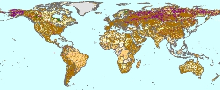
IPCC default soil classes derived from the Harmonized World Soil Data Base, version 1.2
This global data set shows the spatial distribution of generalized soil classes as defined for IPCC Tier-I level national greenhouse gas inventory assessments. The database was derived from the Harmonized World Soil Data Base (HWSD ver. 1.1, at scale 1:1-1:5 M) and a series of taxotransfer procedures to convert FAO soil classifications (1974, 1985 and 1990 Legend) to the seven default IPCC soil classes: high activity clay (HAC), low activity clay (LAC), Sandy (SAN), Spodic (POD), Volcanic (VOL), wetlands (WET) and Organic (ORG). The resulting GIS database may be used for exploratory assessments at national and broader scale, for regions that lack more detailed soil information; inherent limitations of the data are discussed in the documentation.
This dataset has been compiled in the framework of the GEF co-funded 'Carbon Benefits Project: Measuring, modelling and monitoring', Component A ( http://carbonbenefitsproject-compa.colostate.edu/index.htm).
March 2021 (version 1.2): Minor updates were applied for the 'SAN' class; for details see below and download file.
Simple
- Date (Publication)
- 2021-03-12
- Citation identifier
- 41cb0ae9-1604-4807-96e6-0dc8c94c5d22
- Cited responsible party
-
Organisation name Individual name Electronic mail address Role ISRIC - World Soil Information (WDC - Soils)
Niels Batjes
- Presentation form
- Digital map
- Status
- Completed
- Point of contact
-
Organisation name Individual name Electronic mail address Role ISRIC - World Soil Information
Niels Batjes
Author ISRIC - World Soil Information
Data infodesk
Distributor ISRIC - World Soil Information
Data infodesk
Custodian
- Theme
-
-
soil classification
-
-
Stratum
-
-
Soil science
-
-
Region
-
-
Global
-
- Access constraints
- License
- Use constraints
- License
- Other constraints
- Attribution 3.0 International (CC BY 3.0)
- Spatial representation type
- Grid
- Distance
- 30 arc-second
- Language
- English
- Character set
- UTF8
- Topic category
-
- Geoscientific information
- Begin date
- 2000-11-01
- End date
- 2010-11-01
))
- Reference system identifier
- EPSG / 4326
- Distribution format
-
Name Version zip
- Distributor contact
-
Organisation name Individual name Electronic mail address Role ISRIC - World Soil Information
Digital transfer options
- OnLine resource
-
Protocol Linkage Name WWW:DOWNLOAD-1.0-http--download
https://files.isric.org/public/other/IPCC_default_soil_classes_derived_from_the_Harmonized_World_Soil_Data_Base_version_1_2.zip Download v1.2
WWW:LINK-1.0-http--link
https://www.isric.org/sites/default/files/isric_report_2009_02.pdf IPCC default soil classes derived from the Harmonized World Soil Data Base
- Hierarchy level
- Dataset
- Statement
-
- 2021 March (v1.2): Minor changes were applied for SAN class, i.e. ''>70% and <8% clay' in top 0-30 cm)'; rules were applied to 184 map units (flagged as 'DIFF" in column [FLAGsan], see also column [SANDYclass] in the MS Acess file. This change applied to 184 out of a total of 16108 map units; further details are provided in Report 2009/02.
- Batjes NH 2009. IPCC default soil classes derived from the Harmonized World Soil Data Base (Ver. 1.0). Report 2009/02, Carbon Benefits Project (CBP) and ISRIC – World Soil Information, Wageningen (with dataset).
( https://www.isric.org/sites/default/files/isric_report_2009_02.pdf)
Metadata
- File identifier
- 41cb0ae9-1604-4807-96e6-0dc8c94c5d22 XML
- Metadata language
- English
- Character set
- UTF8
- Hierarchy level
- Dataset
- Hierarchy level name
-
dataset
- Date stamp
- 2025-02-05T08:27:21
- Metadata standard name
-
ISO 19115:2003/19139
- Metadata standard version
-
2003/Cor.1:2006
- Metadata author
-
Organisation name Individual name Electronic mail address Role ISRIC - World Soil Information
Data infodesk
Point of contact
)))
