Harmonized World Soil Database (HWSD) version 2.0
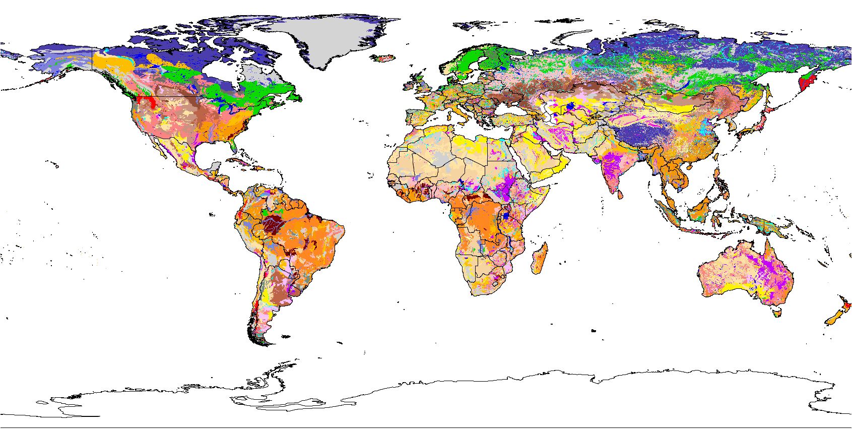
The Harmonized World Soil Database version 2.0 (HWSD v2.0) is a unique global soil inventory providing information on the morphological, chemical and physical properties of soils at approximately 1 km resolution. Its main objective is to serve as a basis for prospective studies on agro-ecological zoning, food security and climate change.
The Harmonized World Soil Database (HWSD) was established in 2008 by the International Institute for Applied Systems Analysis (IIASA) and FAO, and in partnership with International Soil Reference and Information Centre (ISRIC), the European Soil Bureau Network (ESBN) and the Institute for Soil Sciences Chinese Academy of Sciences (CAS). The data entry and harmonization within a Geographic Information System (GIS) was carried out at IIASA, with verification of the database undertaken by all partners. HWSD was then updated in 2013 (HWSD v1.2) and in 2023 (HWSD v2.0).
This updated version (HWSD v2.0) is built on the previous versions of HWSD with several improvements on (i) the data source that now includes several national soil databases, (ii) an enhanced number of soil attributes available for seven soil depth layers, instead of two in HWSD v1.2, and (iii) a common soil reference for all soil units (FAO1990 and the World Reference Base for Soil Resources). This contributes to a further harmonization of the database.
The GIS raster image file is linked to the soil attribute database. The HWSD v2.0 soil attribute database provides information on the soil unit composition for each of the near 30 000 soil association mapping units. The HWSD v2.0 Viewer, provided with the database, creates this link automatically and provides direct access to the soil attribute data and the soil association information.
Note:
- A tutorial for accessing HWSD ver. 2.0 using R (prepared by David Rossiter, June 2023) has been added as an 'associated resource' (NOTE: Needs the SQLite version of HWSD v2 as provided below).
- Soil property estimates in HWSDv2 were derived from Batjes (2016), Geoderma ( https://doi.org/10.1016/j.geoderma.2016.01.034).
Simple
- Date (Publication)
- 2023-02-02
- Citation identifier
- 54aebf11-ec73-4ff8-bf6c-ecff4b0725ea
- Presentation form
- Digital map
- Purpose
-
The Harmonized World Soil Database version 2.0 (HWSD v2.0) is a unique global soil inventory providing information on the morphological, chemical and physical properties of soils at approximately 1 km resolution. Its main objective is to serve as a basis for prospective studies on agro-ecological zoning, food security and climate change.
- Status
- Completed
- Point of contact
-
Organisation name Individual name Electronic mail address Role Food and Agriculture Organization of the United Nations
Freddy Nachtergaele
None
Principal investigator International Institute for Applied Systems Analysis
Harrij van Velthuizen
None
Author International Institute for Applied Systems
Luc Verelst
None
Author International Institute for Applied Systems
Dave Wiberg
None
Author Food and Agriculture Organization of the United Nations
Matieu Henry
Point of contact Food and Agriculture Organization of the United Nations
Federica Chiozza
None
Author Food and Agriculture Organization of the United Nations
Yusuf Yigini
None
Author European Commission - Joint Research Centre
Ece Aksoy
None
Author ISRIC - World Soil Information
Niels H. Batjes
None
Author Food and Agriculture Organization of the United Nations
Enoch Boateng
None
Author International Institute for Applied Systems Analysis
Günther Fischer
None
Author European Commission - Joint Research Centre
Arwyn Jones
None
Author European Commission - Joint Research Centre
Luc Monanarella
None
Author Chinese Academy of Sciences
Xuezheng Shi,
None
Author International Institute for Applied Systems
Sylvia Tramberend
None
Author International Institute for Applied System
None
None
Publisher Food and Agriculture Organization of the United Nations
None
Publisher
- Theme
-
-
soil profiles
-
-
Stratum
-
-
Soil science
-
-
Region
-
-
Global
-
- Access constraints
- License
- Use constraints
- License
- Other constraints
-
Attribution-NonCommercial-ShareAlike 3.0 International (CC BY-NC-SA 3.0), https://creativecommons.org/licenses/by-nc-sa/4.0/
- Spatial representation type
- Grid
- Distance
- 30 arc-second
- Language
- English
- Character set
- UTF8
- Topic category
-
- Geoscientific information
- Begin date
- 2008-01-01
- End date
- 2023-02-01
))
- Reference system identifier
- EPSG / 4326
- Distribution format
-
Name Version HWSD v2
v2
- Distributor contact
-
Organisation name Individual name Electronic mail address Role FAO
Matieu Henry
Publisher
- Distributor contact
-
Organisation name Individual name Electronic mail address Role
Digital transfer options
- OnLine resource
-
Protocol Linkage Name WWW:LINK-1.0-http--related
https://data.apps.fao.org/static/downloads/HWSD/hwsd2_setup_20221216.exe Download data and viewer
WWW:LINK-1.0-http--related
https://hqfao.maps.arcgis.com/apps/dashboards/ab43f3f516364e77998f0c0abf655571 HWSD V.2 Web viewer
WWW:LINK-1.0-http--related
https://gaez.fao.org/pages/hwsd Project webpage
WWW:LINK-1.0-http--link
https://doi.org/10.4060/cc3823en Technical Report and Instructions
WWW:DOWNLOAD-1.0-http--download
https://s3.eu-west-1.amazonaws.com/data.gaezdev.aws.fao.org/HWSD/HWSD2_DB.zip Download HWSD v2 database
WWW:LINK-1.0-http--link
https://www.isric.org/sites/default/files/R_HWSD2.pdf Processing HWSD v2 in R (tutorial)
WWW:LINK-1.0-http--link
https://www.isric.org/sites/default/files/HWSD2.sqlite HWSDv2 SQLite data set (accompanies HWSD v2 in R tutorial)
WWW:LINK-1.0-http--link
https://doi.org/10.1016/j.geoderma.2016.01.034 Harmonized soil property values for broad-scale modelling (WISE30sec)
- Hierarchy level
- Dataset
- Statement
-
Version 2.0 supersedes Version 1.2
Metadata
- File identifier
- 54aebf11-ec73-4ff8-bf6c-ecff4b0725ea XML
- Metadata language
- English
- Character set
- UTF8
- Hierarchy level
- Dataset
- Hierarchy level name
-
dataset
- Date stamp
- 2025-04-10T09:48:31
- Metadata standard name
-
ISO 19115:2003/19139
- Metadata standard version
-
2003/Cor.1:2006
- Metadata author
-
Organisation name Individual name Electronic mail address Role FAO
Matieu Henry
Point of contact IIASA
Contact
Publisher
)))
