Africa Soil Profiles Database, version 1.2
The Africa Soil Profiles Database, Version 1.2, is compiled by ISRIC - World Soil Information (World Data Center for Soils) as a project activity for the Globally integrated- Africa Soil Information Service (AfSIS) project. It replaces version 1.1.
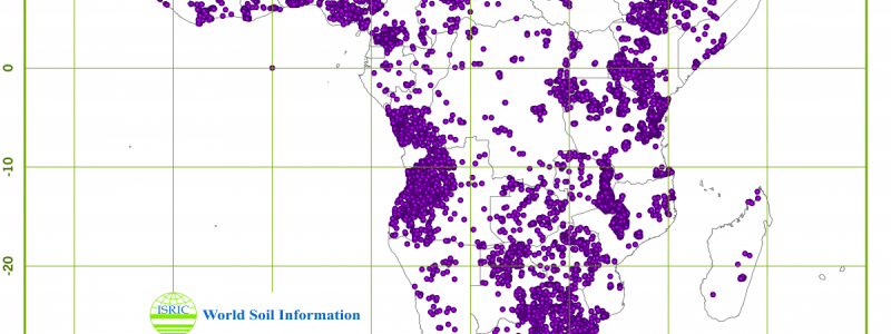
The Africa Soil Profiles Database is a compilation of georeferenced and standardised legacy soil profile data for Sub-Saharan Africa. Version 1.2 (November 2014) identifies 18,532 unique soil profiles inventoried from a wide variety of data sources and includes profile site and layer attribute data. Soil analytical data are available for 15,564 profiles of which 14,197 are georeferenced, including the attributes as specified by the Global Soil Map project. Soil attribute values are standardized according to SOTER conventions and are validated according to routine rules. Odd values are flagged. The degree of validation, and associated reliability of the data, varies because reference soil profile data, that are previously and thoroughly validated, are compiled together with non-reference soil profile data of lesser inherent representativeness.
Simple
- Date (Publication)
- 2014-11-03
- Citation identifier
- b88870b4-6af8-4e78-a3ac-38871d757525
- Presentation form
- Digital map
- Status
- Completed
- Point of contact
-
Organisation name Individual name Electronic mail address Role ISRIC - World Soil Information
Ad van Oostrum
Author ISRIC - World Soil Information
Johan Leenaars
Author ISRIC - World Soil Information
Maria Ruiperez Gonzalez
Author
- Theme
-
-
soil profiles
-
-
Stratum
-
-
Soil science
-
-
Region
-
-
Angola
-
Benin
-
Botswana
-
Burkina Faso
-
Burundi
-
Cameroon
-
Central African Republic
-
Chad
-
Demcratic Republic of the Congo
-
Eswatini
-
Ethiopia
-
Gabon
-
Ghana
-
Guinea
-
Guinea-Bissau
-
Kenya
-
Lesotho
-
Madagascar
-
Malawi
-
Mali
-
Mauritania
-
Mozambique
-
Namibia
-
Niger
-
Nigeria
-
Republic of the Congo
-
Rwanda
-
Senegal
-
Sierra Leone
-
Somalia
-
South Africa
-
South Sudan
-
Sudan
-
Tanzania
-
Togo
-
Uganda
-
Zambia
-
Zimbabwe
-
- Access constraints
- License
- Use constraints
- License
- Other constraints
-
Attribution-NonCommercial 3.0 International (CC BY-NC 3.0), https://creativecommons.org/licenses/by-nc/3.0/
- Spatial representation type
- Vector
- Denominator
- 2500000
- Language
- English
- Character set
- UTF8
- Topic category
-
- Geoscientific information
- Begin date
- 1925-01-01
- End date
- 2011-01-01
))
- Reference system identifier
- EPSG / 4326
- Distribution format
-
Name Version zip
Digital transfer options
- OnLine resource
-
Protocol Linkage Name WWW:DOWNLOAD-1.0-ftp--download
https://files.isric.org/public/afsp/AF-AfSP1.2.zip Download
WWW:LINK-1.0-http--related
https://isric.org/projects/africa-soil-profiles-database-afsp Project webpage
WWW:LINK-1.0-http--related
https://isric.org/sites/default/files/isric_report_2014_01.pdf Report
- Hierarchy level
- Dataset
- Statement
-
The data quality varies, in accordance with the very nature of legacy soil data. The perceived reliability or quality of the data is subjectively rated, at the profile level, 1-4 (high-low).
Metadata
- File identifier
- b88870b4-6af8-4e78-a3ac-38871d757525 XML
- Metadata language
- English
- Character set
- UTF8
- Hierarchy level
- Dataset
- Hierarchy level name
-
dataset
- Date stamp
- 2026-08-14T11:58:00
- Metadata standard name
-
ISO 19115:2003/19139
- Metadata standard version
-
2003/Cor.1:2006
- Metadata author
-
Organisation name Individual name Electronic mail address Role ISRIC - World Soil Information
Data infodesk
Point of contact
)))
