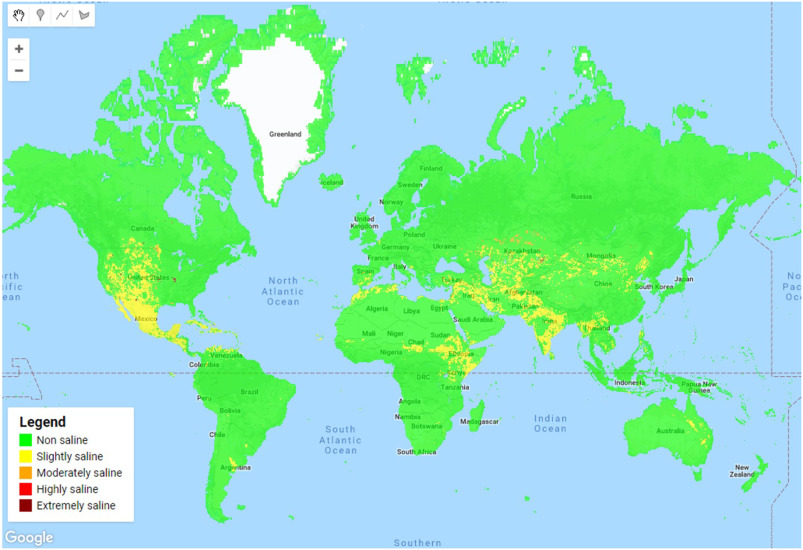
Global Soil Salinity Map
This dataset includes global soil salinity layers for the years 1986, 1992, 2000, 2002, 2005, 2009 and 2016. The maps were generated with a random forest classifier that was trained using seven soil properties maps, thermal infrared imagery and the ECe point data from the WoSIS database. The validation accuracy of the resulting maps was in the range of 67–70%. The total area of salt affected lands by our assessment is around 1 billion hectares, with a clear increasing trend. Further details are provided in a peer-reviewed journal article ( https://doi.org/10.1016/j.rse.2019.111260). The code and data used to produce the global soil salinity maps can be accessed by registered Google Earth Engine users at https://code.earthengine.google.com/d43e5a92ae1deed32a0929f57b572756.
Simple
- Date (Publication)
- 2019-01-01
- Citation identifier
- c59d0162-a258-4210-af80-777d7929c512
- Presentation form
- Digital map
- Status
- Completed
- Point of contact
-
Organisation name Individual name Electronic mail address Role Wageningen University
Harm Bartholomeus
Point of contact ISRIC - World Soil Information
Luis de Sousa
Custodian Wageningen University
Konstantin Ivushkin
Author ISRIC - World Soil Information
Bas Kempen
Custodian
- Theme
-
-
salinity
-
digital soil mapping
-
electrical conductivy
-
global map
-
soilgrids
-
wosis
-
landsat
-
thermal
-
salinisation
-
-
Stratum
-
-
Soil science
-
-
Region
-
-
Global
-
- Access constraints
- License
- Use constraints
- License
- Other constraints
-
Attribution 4.0 International (CC BY 4.0), https://creativecommons.org/licenses/by/4.0/
- Spatial representation type
- Grid
- Distance
- 250 m
- Language
- English
- Character set
- UTF8
- Topic category
-
- Geoscientific information
- Environment
- Begin date
- 1986-01-01
- End date
- 2016-12-31
))
- Reference system identifier
- EPSG / 4326
- Distribution format
-
Name Version GTiff
- Distributor contact
-
Organisation name Individual name Electronic mail address Role ISRIC - World Soil Information
Publisher
Digital transfer options
- OnLine resource
- Hierarchy level
- Dataset
Metadata
- File identifier
- c59d0162-a258-4210-af80-777d7929c512 XML
- Metadata language
- English
- Character set
- UTF8
- Hierarchy level
- Dataset
- Hierarchy level name
-
dataset
- Date stamp
- 2024-11-27T11:04:53
- Metadata standard name
-
ISO 19115:2003/19139
- Metadata standard version
-
2003/Cor.1:2006
- Metadata author
-
Organisation name Individual name Electronic mail address Role ISRIC - World Soil Information
Luis de Sousa
Point of contact Wageningen University
Harm Bartholomeus
Point of contact ISRIC - World Soil Information
Publisher
)))
