WoSIS snapshot - September 2019
The World Soil Information Service (WoSIS) provides quality-assessed and standardised soil profile data to support digital soil mapping and environmental applications at broad scale levels. Since the release of the first ‘WoSIS snapshot’, in July 2016, many new soil data were shared with us, registered in the ISRIC data repository, and subsequently standardised in accordance with the licences specified by the data providers. Soil profile data managed in WoSIS were contributed by a wide range of data providers, therefore special attention was paid to measures for soil data quality and the standardisation of soil property definitions, soil property values (and units of measurement), and soil analytical method descriptions.
We presently consider the following soil chemical properties (organic carbon, total carbon, total carbonate equivalent, total Nitrogen, Phosphorus (extractable-P, total-P, and P-retention), soil pH, cation exchange capacity, and electrical conductivity) and physical properties (soil texture (sand, silt, and clay), bulk density, coarse fragments, and water retention), grouped according to analytical procedures (aggregates) that are operationally comparable.
Further, for each profile, we provide the original soil classification (FAO, WRB, USDA, and version) and horizon designations insofar as these have been specified in the source databases. Measures for geographical accuracy (i.e. location) of the point data as well as a first approximation for the uncertainty associated with the operationally defined analytical methods are presented, for possible consideration in digital soil mapping and subsequent earth system modelling.
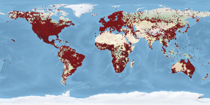
The present snapshot, referred to as ‘WoSIS snapshot - September 2019’, comprises 196,498 geo-referenced profiles originating from 173 countries. They represent over 832 thousand soil layers (or horizons), and over 6 million records. The actual number of observations for each property varies (greatly) between profiles and with depth, this generally depending on the objectives of the initial soil sampling programmes.
The downloadable ZIP file has the data in TSV (tab separated values) and GeoPackage format. It contains the following files:
- ReadmeFirst_WoSIS_2019dec04.pdf (546.7 KB)
- wosis_201909.gpkg (2.2 GB, same data as in the tsv)
- wosis_201909_attributes.tsv (8.7 KB)
- wosis_201909_layers_chemical.tsv (893.5 MB)
- wosis_201909_layers_physical.tsv (890.7 MB)
- wosis_201909_profiles.tsv (18.8 MB)
To read the data in R, please, uncompress the ZIP file and specify the uncompressed folder. Then use read_tsv to read the TSV files, specifying the data types for each column (c = character, i = integer, n = number, d = double, l = logical, f = factor, D = date, T = date time, t = time).
setwd("/YourFolder/WoSIS_2019_September/")
attributes = readr::read_tsv('wosis_201909_attributes.tsv', col_types='cccciicd')
profiles = readr::read_tsv('wosis_201909_profiles.tsv', col_types='icccdddiicccciccccicccc')
chemical = readr::read_tsv('wosis_201909_layers_chemical.tsv', col_types='iiddclcdccccccdccccccdccccccdccccccdccccccdccccccdccccccdccccccdccccccdccccccdccccccdccccccdccccccdccccccdccccccdccccccdccccccdccccccdccccccdccccccdccccc')
physical = readr::read_tsv('wosis_201909_layers_physical.tsv', col_types='iiddclcdccccccdccccccdccccccdccccccdccccccdccccccdccccccdccccccdccccccdccccccdccccccdccccccdccccccdccccccdccccccdccccccdccccccdccccccdccccccdccccccdccccccdccccccdccccccdccccccdccccccdccccccdccccc')
For more detailed instructions on how to read the data with R, please visit https://www.isric.org/accessing-wosis-using-r.
Citation:
Batjes N.H, Ribeiro E, and van Oostrum A.J.M, 2019. Standardised soil profile data for the world (WoSIS snapshot - September 2019), https://doi.org/10.17027/isric-wdcsoils.20190901.
The dataset accompanies the following data paper: Batjes N.H., Ribeiro E., and van Oostrum A.J.M., 2019. Standardised soil profile data to support global mapping and modelling (WoSIS snapshot - 2019). Earth System Science Data, https://doi.org/10.5194/essd-12-299-2020.
Simple
- Date (Publication)
- 2019-09-06
- Citation identifier
- ca880bd4-cff8-11e9-8046-0cc47adaa92c
- Citation identifier
- doi: / 10.17027/isric-wdcsoils.20190901
- Presentation form
- Digital map
- Status
- Completed
- Point of contact
-
Organisation name Individual name Electronic mail address Role ISRIC - World Soil Information
Niels Batjes
Author ISRIC - World Soil Information
Ad van Oostrum
Author ISRIC - World Soil Information
Eloi Ribeiro
Author ISRIC - World Soil Information
Data infodesk
Point of contact
- Theme
-
-
bulk density
-
cation exchange capacity
-
soil classification
-
coarse fragments
-
clay
-
effective cation exchange capacity
-
electrical conductivity
-
organic carbon
-
pH
-
sand
-
silt
-
calcium carbonate
-
texture
-
water retention
-
soil profiles
-
-
Stratum
-
-
Soil science
-
-
Region
-
-
Global
-
- Access constraints
- License
- Use constraints
- License
- Other constraints
-
Licenced per profile, as specified by data provider and indicated in the data
- Spatial representation type
- Vector
- Denominator
- 100000
- Language
- English
- Character set
- UTF8
- Topic category
-
- Geoscientific information
- Begin date
- 1918-01-01
- End date
- 2016-07-05
))
- Reference system identifier
- EPSG / 4326
- Distribution format
-
Name Version Niels H. Batjes
- Distributor contact
-
Organisation name Individual name Electronic mail address Role ISRIC - World Soil Information
Resource provider
Digital transfer options
- OnLine resource
-
Protocol Linkage Name WWW:DOWNLOAD-1.0-ftp--download
https://files.isric.org/public/wosis_snapshot/WoSIS_2019_September.zip Download zip
WWW:LINK-1.0-http--related
https://doi.org/10.5194/essd-12-299-2020 Scientific paper
WWW:LINK-1.0-http--related
https://www.isric.org/explore/wosis/faq-wosis Project webpage
- Hierarchy level
- Dataset
Metadata
- File identifier
- ca880bd4-cff8-11e9-8046-0cc47adaa92c XML
- Metadata language
- English
- Character set
- UTF8
- Hierarchy level
- Dataset
- Hierarchy level name
-
dataset
- Date stamp
- 2023-12-08T11:13:11
- Metadata standard name
-
ISO 19115:2003/19139
- Metadata standard version
-
2003/Cor.1:2006
- Metadata author
-
Organisation name Individual name Electronic mail address Role ISRIC - World Soil Information
Data infodesk
Point of contact
)))
