 ISRIC Data Hub
A homogenized soil data file for global environmental research: A subset of FAO, ISRIC and NRCS profiles
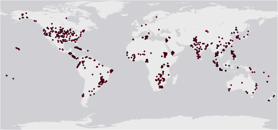
A homogenized, global set of 1,125 soil profiles is presented. These profiles have been extracted from the database developed at ISRIC for a project on "World Inventory of Soil Emission Potentials" (WISE), as a contribution to the activities of the Global Soils Data Task Group of IGBP-DIS. The subset consists of a selection of 665 profiles originating from digital data files released by the Natural Resources Conservation Service (NRCS, Lincoln), 250 profiles obtained from the Food and Agriculture Organization (FAO, Rome), and 210 profiles from the reference collection of the International Soil Reference and Information Centre (ISRIC, Wageningen). All profiles are georeferenced and classified in the FAO-Unesco Legend whereby they can be linked to the edited and digital version of the FAO-Unesco Soil Map of the World. This data set is being released in the public domain for use by global modellers and other interested scientists. It is envisaged that the data set will be expanded by ISRIC when new, uniform soil profile data become available.
Note:
a) A more recent version (some 10,000 profiles) of WISE profiles is available at: http://data.isric.org/geonetwork/srv/eng/catalog.search#/metadata/a351682c-330a-4995-a5a1-57ad160e621c (2009)
b) For a larger compilation see the WoSIS database: http://isric.org/explore/wosis (2017)
Simple
- Date (Publication)
- 1995-07-01
- Identifier
- 0f85c381-e496-47d9-89d8-f1fe2ee1a517
- Presentation form
- Digital map
- Status
- Completed
- Theme
-
- calcium
- carbon
- cation exchange capacity
- electrical conductivity
- nitrogen
- organic carbon
- bulk density
- soil classification
- soil depth
- soil profiles
- pH
- salinity
- texture
- water holding capacity
- soil profiles
- nutrients
- Stratum
-
- Soil science
- Region
-
- Global
- Access constraints
- License
- Use constraints
- License
- Other constraints
- Attribution 3.0 International (CC BY 3.0)
- Spatial representation type
- Grid
- Distance
- 30 arc-second
- Metadata language
- English
- Character set
- UTF8
- Topic category
-
- Geoscientific information
- Begin date
- 1950-01-01
- End date
- 1995-07-01
))
- Reference system identifier
- EPSG / 4326
- Distribution format
-
-
zip
(
)
-
zip
(
)
- OnLine resource
- Download ( WWW:DOWNLOAD-1.0-ftp--download )
- OnLine resource
- Project webpage ( WWW:LINK-1.0-http--related )
- Hierarchy level
- Dataset
- Statement
- Batjes, N.H. (ed.), 1995. A homogenized soil data file for global environmental research: a subset of FAO, ISRICand NRCS profiles (Version 1.0). Working Paper and Preprint 95/10b, International Soil Reference andInformation Centre, Wageningen. https://isric.org/sites/default/files/isric_report_1995_10b.pdf
- File identifier
- 0f85c381-e496-47d9-89d8-f1fe2ee1a517 XML
- Metadata language
- English
- Character set
- UTF8
- Hierarchy level
- Dataset
- Hierarchy level name
- dataset
- Date stamp
- 2025-02-05T10:34:26
- Metadata standard name
- ISO 19115:2003/19139
- Metadata standard version
- 2003/Cor.1:2006
Overviews
Spatial extent
Provided by
