 ISRIC Data Hub
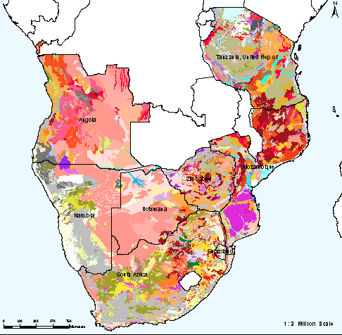
Soil and Terrain Database for Southern Africa (SOTERSAF)
The Soil and Terrain database for Southern Africa (SOTERSAF version 1.0), at scale 1:2 million, include the spatial and soil attribute data for 8 Southern African countries. The SOTERSAF database was compiled using the existing soil information and following the SOTER methodology of the 1:1 million scale with respect to pedon attribute data storage.
The data (SOTERSAF) were compiled in the framework of the ongoing activities of ISRIC, FAO and UNEP to update the world's baseline information on natural resources in SOTER.The project involved collaboration with national soil institutes from the countries in the region as well as individual experts.
Simple
- Date (Publication)
- 2004-10-01
- Identifier
- 3571c1f3-159d-442c-b324-0af53d03f12e
- Presentation form
- Digital map
- Status
- Completed
- Theme
-
- calcium
- carbon
- cation exchange capacity
- electrical conductivity
- nitrogen
- organic matter
- bulk density
- soil profiles
- pH
- salinity
- texture
- water holding capacity
- nutrients
- Stratum
-
- Soil science
- Region
-
- Africa
- Southern Africa
- Angola
- Botswana
- Lesotho
- Mozambique
- Namibia
- South Africa
- Swaziland
- Tanzania
- Zimbabwe
- Access constraints
- License
- Use constraints
- License
- Other constraints
- Attribution 3.0 International (CC BY 3.0)
- Spatial representation type
- Vector
- Denominator
- 2000000
- Metadata language
- English
- Character set
- UTF8
- Topic category
-
- Geoscientific information
- Begin date
- 1951-01-01
- End date
- 2000-11-01
))
- Reference system identifier
- EPSG / 4326
- Distribution format
-
-
zip
(
)
-
zip
(
)
- OnLine resource
- Download ( WWW:DOWNLOAD-1.0-ftp--download )
- OnLine resource
- Project webpage ( WWW:LINK-1.0-http--related )
- OnLine resource
- Report ( WWW:LINK-1.0-http--related )
- Hierarchy level
- Dataset
- Statement
-
Primary data:
1)Dijkshoorn JA 2003. SOTER database for southern Africa (SOTERSAF, ver. 1.0), ISRIC - World Soil Information, Wageningen
2) FAO and ISRIC 2003. Soil and Terrain database for Southern Africa (1:2 million scale). FAO Land and Water Digital Media Series 25, ISRIC and FAO, Rome (http://www.fao.org/icatalog/search/dett.asp?aries_id=104318)
Derived data (needed for modelling):
3) Batjes NH 2004. SOTER-based soil parameter estimates for Southern Africa (ver. 1.0). Report 2004/04, ISRIC - World Soil Information, Wageningen, https://isric.org/sites/default/files/isric_report_2004_04.pdf
- File identifier
- 3571c1f3-159d-442c-b324-0af53d03f12e XML
- Metadata language
- English
- Character set
- UTF8
- Hierarchy level
- Dataset
- Hierarchy level name
- dataset
- Date stamp
- 2024-04-11T12:43:18
- Metadata standard name
- ISO 19115:2003/19139
- Metadata standard version
- 2003/Cor.1:2006
Overviews
Spatial extent
Provided by
