 ISRIC Data Hub
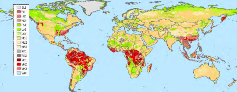
Global distribution of soil phosphorus retention potential
Limited availability of P in soils to crops may be due to deficiency and/or severe P retention. Earlier studies that drew on large soil profile databases have indicated that it is not (yet) feasible to present meaningful values for “plant-available” soil P, obtained according to comparable analytical methods, that may be linked to soil geographical databases derived from 1:5 million scale FAO Digital Soil Map of the World, such as the 5 x 5 arc-minute version of the ISRIC-WISE database. Therefore, an alternative solution for studying possible crop responses to fertilizer-P applied to soils, at a broad scale, was sought. The approach described in this report considers the inherent capacity of soils to retain phosphorus (P retention), in various forms. Main controlling factors of P retention processes, at the broad scale under consideration, are considered to be pH, soil mineralogy, and clay content. First, derived values for these properties were used to rate the inferred capacity for P retention of the component soil units of each map unit (or grid cell) using four classes (i.e., Low, Moderate, High, and Very High). Subsequently, the overall soil phosphorus retention potential was assessed for each mapping unit, taking into account the P-ratings and relative proportion of each component soil unit. Each P retention class has been assigned to a likely fertilizer P recovery fraction, derived from the literature, thereby permitting spatially more detailed, integrated model-based studies of environmental sustainability and agricultural production at the global and continental level (< 1:5 million). Nonetheless, uncertainties remain high; the present analysis provides an approximation of world soil phosphorus retention potential.
- Identification
- Distribution
- Quality
- Spatial rep.
- Ref. system
- Content
- Portrayal
- Metadata
- Md. constraints
- Md. maintenance
- Schema info
Identification
Data identification
Citation
- Date (Publication)
- 2011-06-01
- Identifier
- 36cb1f3a-c0fe-4f99-ba5f-a9f2b4494431
- Presentation form
- Digital map
- Status
- Completed
Author
ISRIC - World Soil Information
-
Niels Batjes
(
Senior Soil Scientist
)
PO Box 353
,
Wageningen
,
6700AJ
,
Netherlands
- Theme
-
- phosphorus
- nutrients
- Stratum
-
- Soil science
- Region
-
- Global
Legal constraints
- Access constraints
- License
- Use constraints
- License
- Other constraints
- Attribution 3.0 International (CC BY 3.0)
- Spatial representation type
- Vector
- Denominator
- 5000000
- Metadata language
- English
- Character set
- UTF8
- Topic category
-
- Geoscientific information
- Begin date
- 2001-06-01
- End date
- 2011-06-01
N
S
E
W
))
Distribution
Distribution
- Distribution format
-
-
zip
(
)
-
zip
(
)
Digital transfer options
- OnLine resource
- Download ( WWW:DOWNLOAD-1.0-ftp--download )
- OnLine resource
- Project webpage ( WWW:LINK-1.0-http--related )
- OnLine resource
- Report ( WWW:LINK-1.0-http--related )
Quality
Data quality
- Hierarchy level
- Dataset
- Statement
- See documentation: https://isric.org/sites/default/files/isric_report_2011_06.pdf
Ref. system
- Reference system identifier
- EPSG / 4326
Metadata
Metadata
- File identifier
- 36cb1f3a-c0fe-4f99-ba5f-a9f2b4494431 XML
- Metadata language
- English
- Character set
- UTF8
- Hierarchy level
- Dataset
- Hierarchy level name
- dataset
- Date stamp
- 2021-07-14T11:51:42
- Metadata standard name
- ISO 19115:2003/19139
- Metadata standard version
- 2003/Cor.1:2006
Overviews
Spatial extent
N
S
E
W
Provided by

Associated resources
Not available