 ISRIC Data Hub
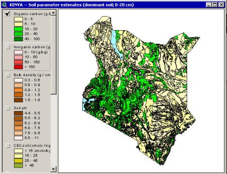
SOTER-based soil parameter estimates (SOTWIS) for Kenya
This harmonized set of soil parameter estimates for Kenya (KENSOTER), at scale 1:1M, compiled by the Kenya Soil Survey. The land surface of the Republic of Kenya - excluding lakes and towns - has been characterized using 397 unique SOTER units corresponding with 623 soil components. The major soils have been described using 495 profiles, which include 178 synthetic profiles, selected by national soil experts as being representative for these units. The associated soil analytical data have been derived from soil survey reports and expert knowledge. Gaps in the measured soil profile data have been filled using a step-wise procedure which includes three main stages: (1) collate additional measured soil analytical data where available; (2) fill gaps using expert knowledge and common sense; (3) fill the remaining gaps using a scheme of taxotransfer rules.
Parameter estimates are presented by soil unit for fixed depth intervals of 0.2 m to 1 m depth for: organic carbon, total nitrogen, pH(H2O), CECsoil, CECclay, base saturation, effective CEC, aluminum saturation, CaCO3 content, gypsum content, exchangeable sodium percentage (ESP), electrical conductivity of saturated paste (ECe), bulk density, content of sand, silt and clay, content of coarse fragments, and available water capacity. These attributes have been identified as being useful for agro-ecological zoning, land evaluation, crop growth simulation, modelling of soil carbon stocks and change, and analyses of global environmental change. The current parameter estimates should be seen as best estimates based on the current selection of soil profiles and data clustering procedure. Taxotransfer rules have been flagged to provide an indication of the possible confidence in the derived data. Results are presented as summary files and can be linked to the 1:1M scale SOTER map for Kenya in a GIS, through the unique SOTER-unit code. The secondary data are considered appropriate for studies at the national scale (1:1M). Correlation of soil analytical data, however, should be done more rigorously when more detailed scientific work is considered.
Simple
- Date (Publication)
- 2004-02-01
- Identifier
- 4648929a-8031-49cc-9d56-9f3aeff2f8d9
- Presentation form
- Digital map
- Status
- Completed
- Theme
-
- calcium
- carbon
- cation exchange capacity
- electrical conductivity
- nitrogen
- organic matter
- bulk density
- soil profiles
- pH
- salinity
- texture
- water holding capacity
- nutrients
- Stratum
-
- Soil science
- Region
-
- Africa
- East-Africa
- Kenya
- Access constraints
- License
- Use constraints
- License
- Other constraints
- Attribution 3.0 International (CC BY 3.0)
- Spatial representation type
- Vector
- Denominator
- 1000000
- Metadata language
- English
- Character set
- UTF8
- Topic category
-
- Geoscientific information
- Begin date
- 1972-11-01
- End date
- 2003-04-01
))
- Reference system identifier
- EPSG / 4326
- Distribution format
-
-
zip
(
)
-
zip
(
)
- OnLine resource
- Download ( WWW:DOWNLOAD-1.0-ftp--download )
- OnLine resource
- Project webpage ( WWW:LINK-1.0-http--related )
- OnLine resource
- Report ( WWW:LINK-1.0-http--related )
- Hierarchy level
- Dataset
- Statement
-
1) Batjes NH and Gicheru P 2004. Soil data derived from SOTER for studies of carbon stocks and change in Kenya (ver. 1.0; GEFSOC Project). Report 2004/01, ISRIC - World Soil Information, Wageningen, https://isric.org/sites/default/files/isric_report_2004_01.pdf
2) Batjes NH 2004. Soil carbon stocks and projected changes according to land use and management: a case study for Kenya. Soil Use and Management 20, 350-356, http://dx.doi.org/10.1111/j.1475-2743.2004.tb00380.x
3) Batjes NH, Al-Adamat R, Bhattacharyya T, Bernoux M, Cerri CEP, Gicheru P, Kamoni P, Milne E, Pal DK and Rawajfih Z 2007. Preparation of consistent soil data sets for SOC modelling purposes: secondary SOTER data sets for four case study areas. Agriculture, Ecosystems and Environment 112, 26-34, http://dx.doi.org/10.1016/j.agee.2007.01.005
4) Kamoni PT, Gicheru PT, Wokabi SM, Easter M, Milne E, Coleman K, Falloon P and Paustian K 2007. Predicted soil organic carbon stocks and changes in Kenya between 1990 and 2030. Agriculture, Ecosystems and Environment 112, 105-113, http://dx.doi.org/10.1016/j.agee.2007.01.012
5) KSS 1995. The soil and terrain database for Kenya at scale 1 million (ver. 1.0). Kenya Soil Survey, National Agricultural Laboratories, Kenya Agricultural Research Institute, Nairobi.
- File identifier
- 4648929a-8031-49cc-9d56-9f3aeff2f8d9 XML
- Metadata language
- English
- Character set
- UTF8
- Hierarchy level
- Dataset
- Hierarchy level name
- dataset
- Date stamp
- 2021-07-14T11:52:19
- Metadata standard name
- ISO 19115:2003/19139
- Metadata standard version
- 2003/Cor.1:2006
Overviews
Spatial extent
Provided by
