 ISRIC Data Hub
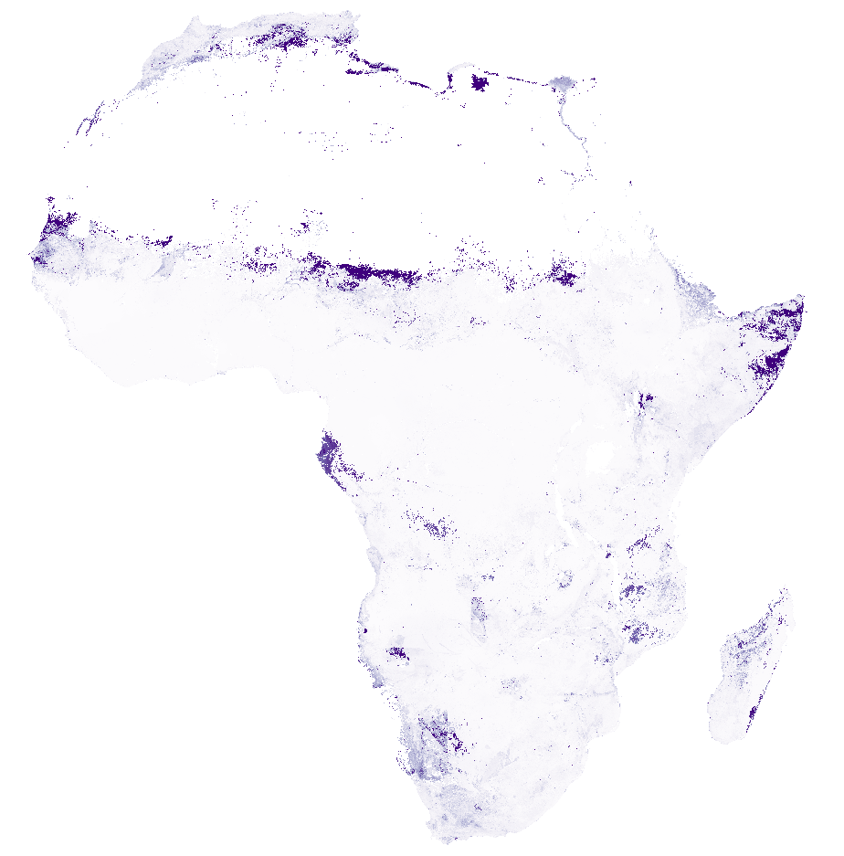
Africa SoilGrids - Electrical conductivity (EC)
Simple
- Date (Publication)
- 2015-02-10
- Identifier
- 59455180-29b7-4e9c-95ab-4d6c03ca19c7
- Presentation form
- Digital map
- Status
- Completed
- Theme
-
- electrical conductivity
- digital soil mapping
- Stratum
-
- Soil science
- Region
-
- Africa
- Access constraints
- License
- Use constraints
- License
- Other constraints
- Attribution-NonCommercial 3.0 International (CC BY-NC 3.0), https://creativecommons.org/licenses/by-nc/3.0/
- Spatial representation type
- Grid
- Distance
- 250 m
- Metadata language
- English
- Character set
- UTF8
- Topic category
-
- Geoscientific information
- Begin date
- 1960-01-01
- End date
- 2015-12-31
))
- Reference system identifier
- proj4 / +proj=laea +lat_0=5 +lon_0=20 +x_0=0 +y_0=0 +datum=WGS84 +units=m +no_defs
- Distribution format
-
-
GTiff
(
)
-
GTiff
(
)
- OnLine resource
- Download GeoTIFF at depth 0-5 cm ( WWW:DOWNLOAD-1.0-ftp--download )
- OnLine resource
- Download GeoTIFF at depth 5-15 cm ( WWW:DOWNLOAD-1.0-ftp--download )
- OnLine resource
- Download GeoTIFF at depth 15-30 cm ( WWW:DOWNLOAD-1.0-ftp--download )
- OnLine resource
- Download GeoTIFF at depth 30-60 cm ( WWW:DOWNLOAD-1.0-ftp--download )
- OnLine resource
- Download GeoTIFF at depth 60-100 cm ( WWW:DOWNLOAD-1.0-ftp--download )
- OnLine resource
- Download GeoTIFF at depth 100-200 cm ( WWW:DOWNLOAD-1.0-ftp--download )
- OnLine resource
- Project webpage ( WWW:LINK-1.0-http--related )
- OnLine resource
- Scientific paper ( WWW:LINK-1.0-http--related )
- Hierarchy level
- Dataset
- Statement
-
Project webpages: http://africasoils.net/
http://isric.org/projects/africa-soil-information-service-afsis
Soil data (1): http://isric.org/projects/africa-soil-profiles-database-afsp
Not included: Soil data (2): http://africasoils.net/services/data/soil-databases/
- File identifier
- 59455180-29b7-4e9c-95ab-4d6c03ca19c7 XML
- Metadata language
- English
- Character set
- UTF8
- Hierarchy level
- Dataset
- Hierarchy level name
- dataset
- Date stamp
- 2021-07-14T11:51:48
- Metadata standard name
- ISO 19115:2003/19139
- Metadata standard version
- 2003/Cor.1:2006
Overviews
Spatial extent
Provided by
