 ISRIC Data Hub
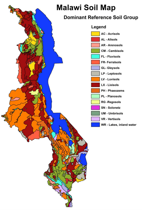
Soil and Terrain Database (SOTER) for Malawi
The Soil and Terrain database for Malawi (version 1.0), at scale 1:1 million, was compiled based on the soil map of Malawi at scale 1:250,000 (compiled by the Land Resources Evaluation Project) that was complemented with soil boundary information from the provisional soil map at scale 1:1 million. The 90m SRTM-DEM was used to define the various landform types of the SOTER units and also to adjust their boundaries. The SOTER map units were attributed with soil information obtained from the Africa Soil Profiles Database. The SOTER compilation followed the methodology described in the SOTER Procedures Manual Version 2.
SOTER forms a part of the ongoing activities of ISRIC, FAO and UNEP to update the world's baseline information on natural resources.The project involved collaboration with national soil institutes from the countries in the region as well as individual experts.
DOI for dataset (submitted): 10.17027/isric.wdcsoils.20160002
INSPIRE
Identification
- File identifier
- 60803da0-a15f-4cc5-9cb5-172fa2460af3 XML
- Hierarchy level
- Dataset
Online resource
- Protocol
- WWW:DOWNLOAD-1.0-ftp--download
- Protocol
- WWW:LINK-1.0-http--related
- Protocol
- WWW:LINK-1.0-http--related
Resource identifier
- code
- 60803da0-a15f-4cc5-9cb5-172fa2460af3
- Metadata language
- English
- Spatial representation type
- Vector
Encoding
- Format
- zip
Projection
- code
- 4326
Classification of data and services
- Topic category
-
- Geoscientific information
Classification of data and services
Coupled resource
Coupled resource
Classification of data and services
Coupled resource
Coupled resource
Keywords
- Stratum
-
- Soil science
- Region
-
- Africa
- Malawi
Other keywords
- Theme
-
- calcium
- carbon
- cation exchange capacity
- electrical conductivity
- nitrogen
- organic matter
- bulk density
- soil profiles
- pH
- salinity
- texture
- water holding capacity
- nutrients
Geographic coverage
))
Temporal reference
Temporal extent
- Begin
- 1968-09-01
- End
- 1998-08-30
Temporal extent
- Date (Publication)
- 2006-01-01
Quality and validity
- Lineage
- Dijkshoorn JA, Leenaars JGB, Huting J and Kempen B 2016. Report 2016/01, ISRIC―World Soil Information, Wageningen (doi:10.17027/isric-wdcsoils.20160001, with dataset). http://isric.org/sites/default/files/isric_report_2016_01.pdf
- Denominator
- 1000000
Conformity
Conformity
Conformity
Conformity
Conformity
Conformity
Restrictions on access and use
- Access constraints
- Attribution-NonCommercial 3.0 International (CC BY-NC 3.0), https://creativecommons.org/licenses/by-nc/3.0/
Responsible organization (s)
Contact for the resource
- Organisation name
- ISRIC - World Soil Information
- bas.kempen@wur.nl
- Organisation name
- ISRIC - World Soil Information
- johan.leenaars@wur.nl
- Organisation name
- ISRIC - World Soil Information
- None
Responsible organization (s)
Contact for the resource
- Organisation name
- ISRIC - World Soil Information
- bas.kempen@wur.nl
- Organisation name
- ISRIC - World Soil Information
- johan.leenaars@wur.nl
- Organisation name
- ISRIC - World Soil Information
- None
Metadata information
Contact for the metadata
- Organisation name
- ISRIC - World Soil Information
- data@isric.org
- Date stamp
- 2021-07-14T11:52:35
- Metadata language
- English
- Character set
- UTF8
SDS
Conformance class 1: invocable
Access Point URL
Endpoint URL
Technical specification
Conformance class 2: interoperable
Access constraints
Limitation
Use constraints
Limitation
Responsible custodian
Contact for the resource
Overviews
Spatial extent
Provided by
