 ISRIC Data Hub
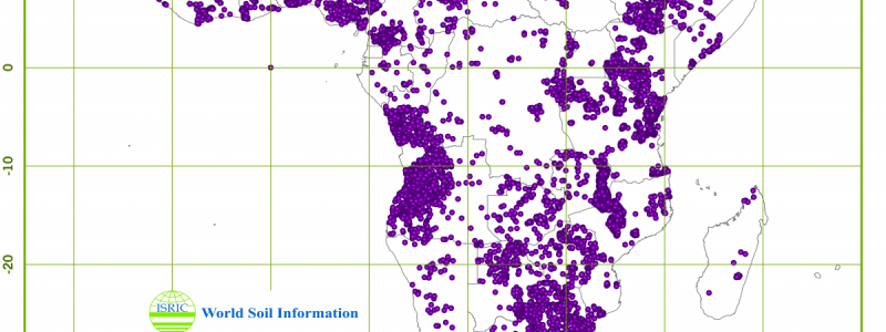
Africa Soil Profiles Database, version 1.0
ISRIC World Soil Information is compiling legacy soil profile data of Sub Saharan Africa, as a project activity of the AfSIS project (Globally integrated Africa Soil Information Service). http://africasoils.net/services/data/soil-databases/
Africa Soil Profiles database, version. 1.0 (April 2012) identifies less than 15700 unique soil profiles inventoried from a wide variety of data sources. From the less than 14600 profiles that are geo-referenced, soil layer attribute data are available for less than 12500 and soil analytical data for less than 10000 profiles. The database includes, but is not limited, to the soil attributes specified by GlobalSoilMap.net. Soil attribute values are standardized according to e-SOTER conventions and validated according to routine rules. Odd values are flagged. The degree of validation, and associated reliability of the data, varies because reference soil profile data, that are previously and thoroughly validated, are compiled together with non-reference soil profile data of lesser inherent representativeness.
Updated milestone versions of the dataset have been posted online and made available to the project serving as input to the soil property maps generated by AfSIS. The continuously growing dataset will also be made available through the World Soil Information Service upon continuation of the project activity. The version is released here is version 1.0., the latest version is 1.1.
Simple
- Date (Publication)
- 2012-03-29
- Identifier
- 6fd2f113-9c67-49a4-99e1-8c6c7d4d5e72
- Presentation form
- Digital map
- Status
- Completed
- Theme
-
- soil profiles
- Stratum
-
- Soil science
- Region
-
- Angola
- Benin
- Botswana
- Burkina Faso
- Burundi
- Cameroon
- Central African Republic
- Chad
- Demcratic Republic of the Congo
- Eswatini
- Ethiopia
- Gabon
- Ghana
- Guinea
- Guinea-Bissau
- Kenya
- Lesotho
- Madagascar
- Malawi
- Mali
- Mauritania
- Mozambique
- Namibia
- Niger
- Nigeria
- Republic of the Congo
- Rwanda
- Senegal
- Sierra Leone
- Somalia
- South Africa
- South Sudan
- Sudan
- Tanzania
- Togo
- Uganda
- Zambia
- Zimbabwe
- Access constraints
- License
- Use constraints
- License
- Other constraints
- Attribution-NonCommercial 3.0 International (CC BY-NC 3.0), https://creativecommons.org/licenses/by-nc/3.0/
- Spatial representation type
- Vector
- Denominator
- 2500000
- Metadata language
- English
- Character set
- UTF8
- Topic category
-
- Geoscientific information
- Begin date
- 1925-01-01
- End date
- 2011-01-01
))
- Reference system identifier
- EPSG / 4326
- Distribution format
-
-
zip
(
)
-
zip
(
)
- OnLine resource
- Download ( WWW:DOWNLOAD-1.0-ftp--download )
- OnLine resource
- Project webpage ( WWW:LINK-1.0-http--related )
- OnLine resource
- Report ( WWW:LINK-1.0-http--related )
- Hierarchy level
- Dataset
- Statement
- The data quality varies, in accordance with the very nature of legacy soil data. The perceived reliability or quality of the data is subjectively rated, at the profile level, 1-4 (high-low).
- File identifier
- 6fd2f113-9c67-49a4-99e1-8c6c7d4d5e72 XML
- Metadata language
- English
- Character set
- UTF8
- Hierarchy level
- Dataset
- Hierarchy level name
- dataset
- Date stamp
- 2021-07-14T11:51:39
- Metadata standard name
- ISO 19115:2003/19139
- Metadata standard version
- 2003/Cor.1:2006
Overviews
Spatial extent
Provided by
