 ISRIC Data Hub
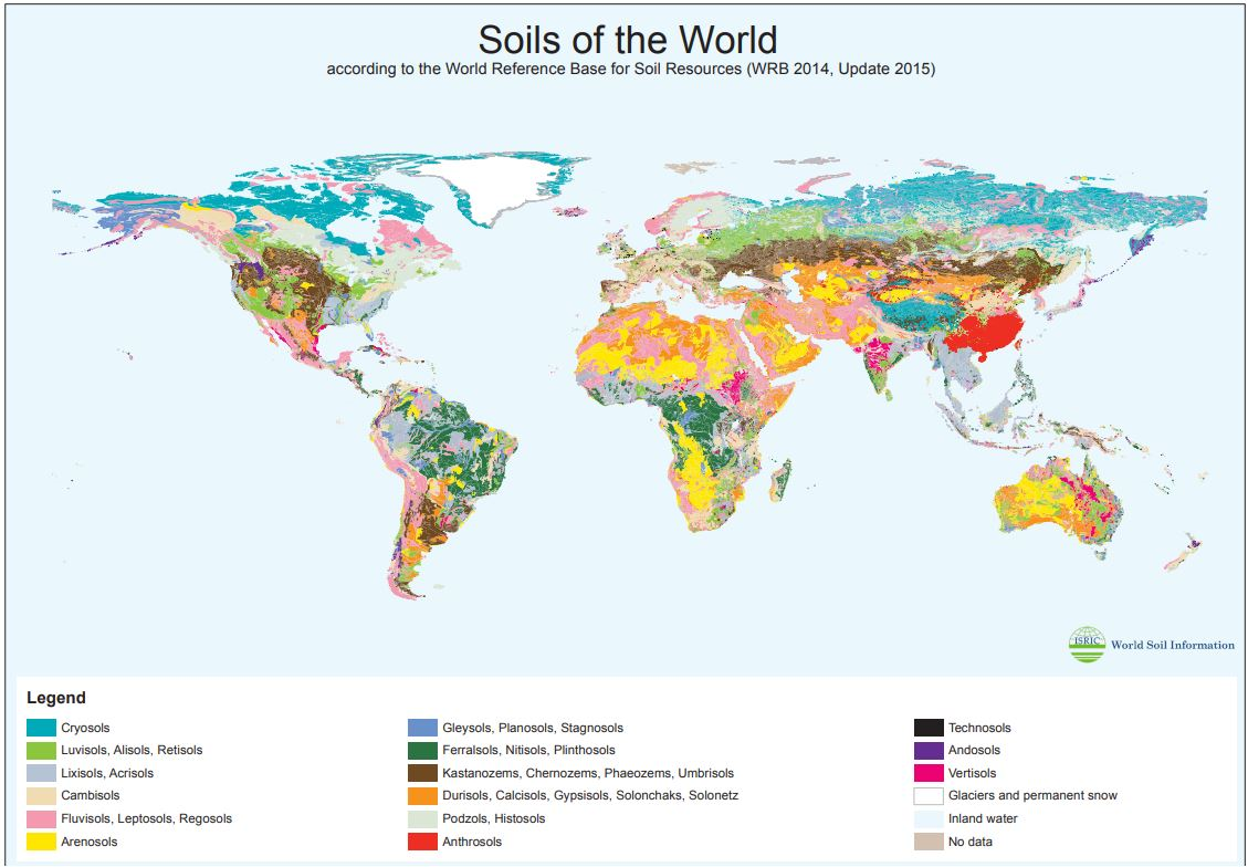
Soils of the World, according to the World Reference Base for Soil Resources (WRB 2014, Update 2015)
This map was prepared based on the Harmonised World Soil Database (HSWD), v1.2 and using the World Reference Base for Soil Resources (WRB) 2014, update 2015. The map units were derived from aggregation of the HWSD units using the ‘soil associations’ as defined in the short key of the WRB2014 document.
The aggregated World Soil Map map was prepared at ISRIC on request of the Heinrich-Boell-Stiftung.
Simple
- Date (Publication)
- 2015-09-01
- Identifier
- 71203238-9817-4a4e-a626-6e89a47d501a
- Presentation form
- Digital map
- Status
- Completed
- Theme
-
- Stratum
-
- Soil science
- Place
-
- Global
- Access constraints
- License
- Use constraints
- License
- Other constraints
- Open Database License (ODbl) v1.0
- Spatial representation type
- Grid
- Distance
- 5000000 m
- Metadata language
- English
- Character set
- UTF8
- Topic category
-
- Geoscientific information
- Begin date
- 1950-01-01
- End date
- 2015-12-01
))
- Reference system identifier
- EPSG / 4326
- Distribution format
-
-
(
)
-
(
)
- OnLine resource
-
Generalised WRB 2014 map (GIS files zipped)
(
WWW:LINK-1.0-http--link
)
Zipped file
- OnLine resource
-
World reference base for soil resources 2014 (Update 2015)
(
WWW:LINK-1.0-http--link
)
Report
- OnLine resource
- Generalised WRB soil map (poster format) ( WWW:LINK-1.0-http--link )
- Hierarchy level
- Dataset
- File identifier
- 71203238-9817-4a4e-a626-6e89a47d501a XML
- Metadata language
- English
- Character set
- UTF8
- Hierarchy level
- Dataset
- Hierarchy level name
- dataset
- Date stamp
- 2024-03-04T07:34:16
- Metadata standard name
- ISO 19119
- Metadata standard version
- 2003/Cor.1:2006
Overviews
Spatial extent
Provided by
