 ISRIC Data Hub
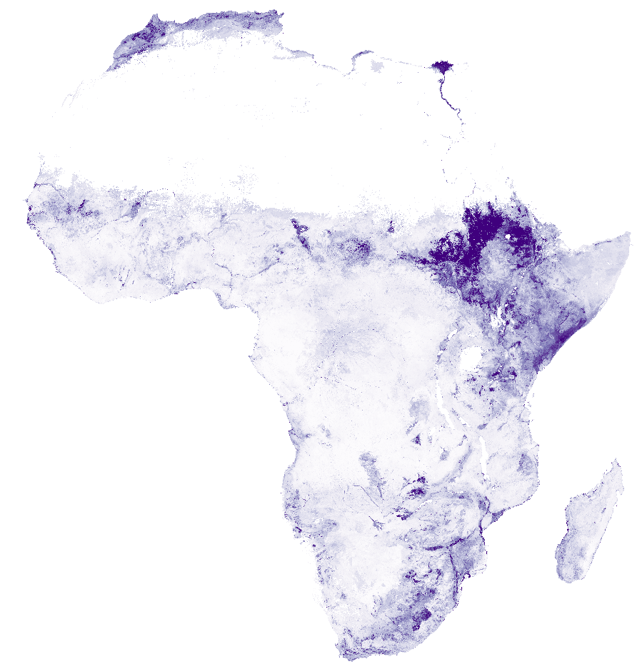
Africa SoilGrids - Exchangeable magnesium (Mg2+)
Exchangeable magnesium (Mg2+ measured in 1M NH4OAc buffered at pH 7 with part of the data converted from data measured according to Mehlich 3) in cmolc/kg (fine earth) at 2 depth intervals (0-20 cm and 20-50 cm) predicted using two Africa soil profiles datasets. For details see published paper here below (Hengl T., G.B.M. Heuvelink, B. Kempen, J.G.B. Leenaars, M.G. Walsh, K.D. Shepherd, A. Sila, R.A. MacMillan, J. Mendes de Jesus, L.T. Desta, J.E. Tondoh, 2015. Mapping Soil Properties of Africa at 250 m Resolution: Random Forests Significantly Improve Current Predictions. PLoS ONE 10(6)
INSPIRE
Identification
- File identifier
- cd1aee58-bb92-44b4-ad3a-a5bc2dc6db7e XML
- Hierarchy level
- Dataset
Online resource
- Protocol
- WWW:DOWNLOAD-1.0-ftp--download
- Protocol
- WWW:DOWNLOAD-1.0-ftp--download
- Protocol
- WWW:LINK-1.0-http--related
- Protocol
- WWW:LINK-1.0-http--related
Resource identifier
- code
- cd1aee58-bb92-44b4-ad3a-a5bc2dc6db7e
- Metadata language
- English
- Spatial representation type
- Grid
Encoding
- Format
- GTiff
Projection
- code
- +proj=laea +lat_0=5 +lon_0=20 +x_0=0 +y_0=0 +datum=WGS84 +units=m +no_defs
Classification of data and services
- Topic category
-
- Geoscientific information
Classification of data and services
Coupled resource
Coupled resource
Classification of data and services
Coupled resource
Coupled resource
Keywords
- Stratum
-
- Soil science
- Region
-
- Africa
Other keywords
- Theme
-
- magnesium
- digital soil mapping
- nutrients
Geographic coverage
N
S
E
W
))
Temporal reference
Temporal extent
- Begin
- 1960-01-01
- End
- 2015-12-31
Temporal extent
- Date (Publication)
- 2015-02-10
Quality and validity
- Lineage
-
Project webpages: http://africasoils.net/
http://isric.org/projects/africa-soil-information-service-afsis
Soil data (1): http://isric.org/projects/africa-soil-profiles-database-afsp
Not included: Soil data (2): http://africasoils.net/services/data/soil-databases/
- Distance
- 250 m
Conformity
Conformity
Conformity
Conformity
Conformity
Conformity
Restrictions on access and use
- Access constraints
- Attribution-NonCommercial 3.0 International (CC BY-NC 3.0), https://creativecommons.org/licenses/by-nc/3.0/
Responsible organization (s)
Contact for the resource
- Organisation name
- ISRIC - World Soil Information
- johan.leenaars@wur.nl
- Organisation name
- ISRIC - World Soil Information
- None
Responsible organization (s)
Contact for the resource
- Organisation name
- ISRIC - World Soil Information
- johan.leenaars@wur.nl
- Organisation name
- ISRIC - World Soil Information
- None
Metadata information
Contact for the metadata
- Organisation name
- ISRIC - World Soil Information
- data@isric.org
- Date stamp
- 2021-07-14T11:52:13
- Metadata language
- English
- Character set
- UTF8
SDS
Conformance class 1: invocable
Access Point URL
Endpoint URL
Technical specification
Conformance class 2: interoperable
Access constraints
Limitation
Use constraints
Limitation
Responsible custodian
Contact for the resource
Overviews
Spatial extent
N
S
E
W
Provided by

Associated resources
Not available