 ISRIC Data Hub
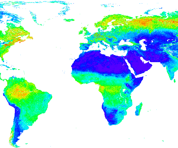
SoilGrids250m 2017-03 - Soil pH x 10 in KCl
Soil pH x 10 in KCl at 7 standard depths (to convert to pH values divide by 10) predicted using the global compilation of soil ground observations. Accuracy assessement of the maps is availble in Hengl et at. (2017) DOI: 10.1371/journal.pone.0169748. Data provided as GeoTIFFs with internal compression (co='COMPRESS=DEFLATE'). Measurement units: NA.
Simple
- Date (Publication)
- 2017-06-01
- Identifier
- d6633978-ae41-4529-b2c7-22560213ad76
- Presentation form
- Digital map
- Status
- Completed
Principal investigator
ISRIC - World Soil Information
-
Bas Kempen
(
Soil mapping specialist
)
PO Box 353
,
Wageningen
,
6700AJ
,
Netherlands
Author
ISRIC - World Soil Information
-
Tom Hengl
(
Former staff
)
PO Box 353
,
Wageningen
,
6700AJ
,
Netherlands
- Theme
-
- pH
- digital soil mapping
- Stratum
-
- Soil science
- Region
-
- Global
- Access constraints
- License
- Use constraints
- License
- Other constraints
- Open Database License (ODbl) v1.0
- Spatial representation type
- Grid
- Distance
- 250 m
- Metadata language
- English
- Character set
- UTF8
- Topic category
-
- Geoscientific information
- Begin date
- 1950-01-01
- End date
- 2015-12-01
N
S
E
W
))
- Reference system identifier
- EPSG / 4326
- Distribution format
-
-
GTiff
(
)
-
GTiff
(
)
- OnLine resource
- Download GeoTIFF at depth 0 cm ( WWW:DOWNLOAD-1.0-ftp--download )
- OnLine resource
- Download GeoTIFF at depth 5 cm ( WWW:DOWNLOAD-1.0-ftp--download )
- OnLine resource
- Download GeoTIFF at depth 15 cm ( WWW:DOWNLOAD-1.0-ftp--download )
- OnLine resource
- Download GeoTIFF at depth 30 cm ( WWW:DOWNLOAD-1.0-ftp--download )
- OnLine resource
- Download GeoTIFF at depth 60 cm ( WWW:DOWNLOAD-1.0-ftp--download )
- OnLine resource
- Download GeoTIFF at depth 100 cm ( WWW:DOWNLOAD-1.0-ftp--download )
- OnLine resource
- Download GeoTIFF at depth 200 cm ( WWW:DOWNLOAD-1.0-ftp--download )
- OnLine resource
- Scientific paper ( WWW:LINK-1.0-http--related )
- OnLine resource
- Project webpage ( WWW:LINK-1.0-http--related )
- Hierarchy level
- Dataset
- File identifier
- d6633978-ae41-4529-b2c7-22560213ad76 XML
- Metadata language
- English
- Character set
- UTF8
- Hierarchy level
- Dataset
- Hierarchy level name
- dataset
- Date stamp
- 2021-07-14T11:52:38
- Metadata standard name
- ISO 19115:2003/19139
- Metadata standard version
- 2003/Cor.1:2006
Overviews
Spatial extent
N
S
E
W
Provided by

Associated resources
Not available