 ISRIC Data Hub
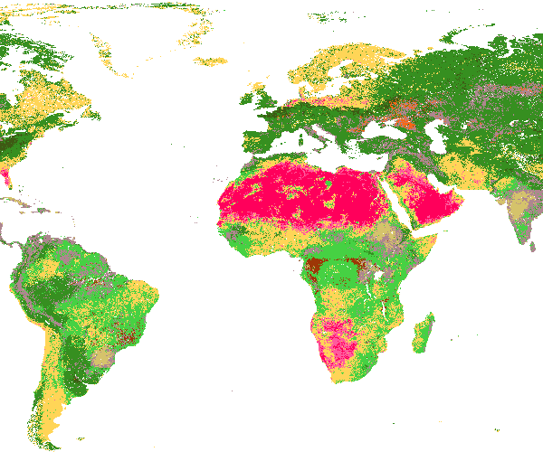
SoilGrids250m 2017-03 - Texture class (USDA system)
Texture class (USDA system) at 7 standard depths predicted using the global compilation of soil ground observations. Accuracy assessement of the maps is availble in Hengl et at. (2017) DOI: 10.1371/journal.pone.0169748. Data provided as GeoTIFFs with internal compression (co='COMPRESS=DEFLATE')
Simple
- Date (Publication)
- 2017-06-01
- Identifier
- f9a3a4e0-27a8-4acc-861f-26c112699c3e
- Presentation form
- Digital map
- Status
- Completed
Principal investigator
ISRIC - World Soil Information
-
Bas Kempen
(
Soil mapping specialist
)
PO Box 353
,
Wageningen
,
6700AJ
,
Netherlands
Author
ISRIC - World Soil Information
-
Tom Hengl
(
Former staff
)
PO Box 353
,
Wageningen
,
6700AJ
,
Netherlands
- Theme
-
- texture
- digital soil mapping
- Stratum
-
- Soil science
- Region
-
- Global
- Access constraints
- License
- Use constraints
- License
- Other constraints
- Open Database License (ODbl) v1.0
- Spatial representation type
- Grid
- Distance
- 250 m
- Metadata language
- English
- Character set
- UTF8
- Topic category
-
- Geoscientific information
- Begin date
- 1950-01-01
- End date
- 2015-12-01
N
S
E
W
))
- Reference system identifier
- EPSG / 4326
- Distribution format
-
-
GTiff
(
)
-
GTiff
(
)
- OnLine resource
- Download GeoTIFF at depth 0 cm ( WWW:DOWNLOAD-1.0-ftp--download )
- OnLine resource
- Download GeoTIFF at depth 5 cm ( WWW:DOWNLOAD-1.0-ftp--download )
- OnLine resource
- Download GeoTIFF at depth 15 cm ( WWW:DOWNLOAD-1.0-ftp--download )
- OnLine resource
- Download GeoTIFF at depth 30 cm ( WWW:DOWNLOAD-1.0-ftp--download )
- OnLine resource
- Download GeoTIFF at depth 60 cm ( WWW:DOWNLOAD-1.0-ftp--download )
- OnLine resource
- Download GeoTIFF at depth 100 cm ( WWW:DOWNLOAD-1.0-ftp--download )
- OnLine resource
- Download GeoTIFF at depth 200 cm ( WWW:DOWNLOAD-1.0-ftp--download )
- OnLine resource
- Scientific paper ( WWW:LINK-1.0-http--related )
- OnLine resource
- Project webpage ( WWW:LINK-1.0-http--related )
- Hierarchy level
- Dataset
- File identifier
- f9a3a4e0-27a8-4acc-861f-26c112699c3e XML
- Metadata language
- English
- Character set
- UTF8
- Hierarchy level
- Dataset
- Hierarchy level name
- dataset
- Date stamp
- 2021-07-14T11:51:34
- Metadata standard name
- ISO 19115:2003/19139
- Metadata standard version
- 2003/Cor.1:2006
Overviews
Spatial extent
N
S
E
W
Provided by

Associated resources
Not available