 ISRIC Data Hub
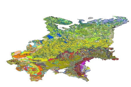
SOTER-based soil parameter estimates (SOTWIS) for Central and Eastern Europe, version 2.0
This harmonized set of soil parameter estimates for Central and Eastern Europe has been derived from a revised version of the 1:2.5M Soil and Terrain (SOTER) Database for Central and Eastern Europe (SOVEUR ver. 1.1) and the ISRIC-WISE soil profile database.
The land surface of Central and Eastern Europe, West of the Ural Mountains, has been characterized using 8361 unique maps or SOTER units. The corresponding GIS files include some 9500 mapped polygons, including miscellaneous units. The major soils have been described using 662 profiles, selected by national soil experts as being representative for these units. The associated soil analytical data have been derived from soil survey reports. These sources seldom hold all the physical and chemical attributes ideally required by SOTER. Gaps in the measured soil profile data have been filled using a procedure that uses taxotransfer rules, based on about 9600 soil profiles held in the WISE database, complemented with expert-rules.
Parameter estimates are presented by soil unit for fixed depth intervals of 0.2 m to 1 m depth for: organic carbon, total nitrogen, pH(H2O), CECsoil, CECclay, base saturation, effective CEC, aluminium saturation, CaCO3 content, gypsum content, exchangeable sodium percentage (ESP), electrical conductivity of saturated paste (ECe), bulk density, content of sand, silt and clay, content of coarse fragments (less than 2 mm), and available water capacity (-33 to -1500 kPa). These attributes have been identified as being useful for agro-ecological zoning, land evaluation, crop growth simulation, modelling of soil carbon stocks and change, and analyses of global environmental change.
The current parameter estimates should be seen as best estimates based on the current selection of soil profiles and data clustering procedure; taxotransfer rules have been flagged to provide an indication of the confidence in the derived data.
Results are presented as summary files and can be linked to the 1:2.5M scale SOVEUR map in a GIS, through the unique SOTER-unit code. The secondary data are considered appropriate for studies at the continental scale (greater than1:2.5 million); correlation of soil analytical data should be done more rigorously when more detailed scientific work is considered.
Simple
- Date (Publication)
- 2000-01-01
- Identifier
- f9f23e4f-903a-4dfe-bfc4-0e6bf362b09a
- Presentation form
- Digital map
- Status
- Completed
- Theme
-
- calcium
- carbon
- cation exchange capacity
- electrical conductivity
- nitrogen
- organic matter
- bulk density
- soil profiles
- pH
- salinity
- texture
- water holding capacity
- nutrients
- Stratum
-
- Soil science
- Region
-
- Europe
- Eastern Europe
- Central Europe
- Bulgaria
- Czech Republic
- Belarus
- Hungary
- Moldova
- Poland
- Romania
- Russia
- Slovakia
- Ukraine
- Estonia
- Latvia
- Lithuania
- Access constraints
- License
- Use constraints
- License
- Other constraints
- Attribution 3.0 International (CC BY 3.0)
- Spatial representation type
- Vector
- Denominator
- 2500000
- Metadata language
- English
- Character set
- UTF8
- Topic category
-
- Geoscientific information
- Begin date
- 1930-07-01
- End date
- 1997-09-01
))
- Reference system identifier
- EPSG / 4326
- Distribution format
-
-
zip
(
)
-
zip
(
)
- OnLine resource
- Download ( WWW:DOWNLOAD-1.0-ftp--download )
- OnLine resource
- Project webpage ( WWW:LINK-1.0-http--related )
- OnLine resource
- Report ( WWW:LINK-1.0-http--related )
- Hierarchy level
- Dataset
- Statement
-
1) Batjes NH 1999. Soil vulnerability mapping in Central and Eastern Europe: Issues of data acquisition, quality control and sharing. In: Naff T (editor), Data Sharing for International Water Resource Management: Eastern Europe, Russia and the CIS. NATO Science Series 2: Environmental Security (Vol. 61). Kluwer Academic Publishers, Dordrecht, pp 187-206
2) Batjes NH 2002. Carbon and nitrogen stocks in the soils of Central and Eastern Europe. Soil Use and Management 18, 324-329, http:\\dx.doi.org\ 10.1111/j.1475-2743.2002.tb00248.x
3) Batjes NH 2003. A taxotransfer rule-based approach for filling gaps in measured soil data in primary SOTER databases (GEFSOC Project). Report 2003/03, ISRIC - World Soil Information, Wageningen.
4) Batjes NH 2005. SOTER-based soil parameter estimates for Central and Eastern Europe (ver. 2.0). Report 2005/04, ISRIC - World Soil Information, Wageningen,https://isric.org/sites/default/files/isric_report_2005_04.pdf
5) Batjes NH and Bridges EM 1997. Implementation of a Soil Degradation and Vulnerability Database for Central and Eastern Europe. Proceedings of an international workshop (Wageningen, 1-3 October 1997) (also available on CD No.10, Land and Water Digital Media Series, FAO, 2000), ISRIC, Wageningen
6) Batjes NH and Bridges EM 2000. Development of a soil degradation and vulnerability database for Central and Eastern Europe (SOVEUR Project). Eurasian Soil Science 33, 230-232 (Translated from Pochvovedenie No. 2, 2000, pp. 262-265)
7) FAO and ISRIC 2000. Soil and terrain database, soil degradation status, and soil vulnerability assessments for Central and Eastern Europe (scale 1:2.5 million; ver. 1.0). Land and Water Digital Media Series 10, FAO, Rome
8) Nachtergaele FO, van Lynden GWJ and Batjes NH 2002. Soil and terrain databases and their applications with special reference to physical soil degradation and soil vulnerability to pollution in central and eastern Europe. In: Pagliaia M and R Jones (editors), Advances in GeoEcology 35. CATENA Verlag GMBH, Reiskrirchen
- File identifier
- f9f23e4f-903a-4dfe-bfc4-0e6bf362b09a XML
- Metadata language
- English
- Character set
- UTF8
- Hierarchy level
- Dataset
- Hierarchy level name
- dataset
- Date stamp
- 2021-07-14T11:51:39
- Metadata standard name
- ISO 19115:2003/19139
- Metadata standard version
- 2003/Cor.1:2006
Overviews
Spatial extent
Provided by
